(2006-08-26)
A frequently updated postcard of pictures and photos showing the beauty of British Columbia
Sunday, July 23, 2017
North Vancouver - Lone Rock Point in Indian Arm
On this gorgeous day in August (2006-08-31), Hanne and I set off kayaking, heading for Jug, Raccoon, and Twin Islands. We launched in Deep Cove and made our way along the North Vancouver shore before planning to cross Indian Arm, over to our destination islands. Off the shore we took our postcard picture at Lone Rock Point.
![]() |
| Lone Rock Point in Indian Arm... |
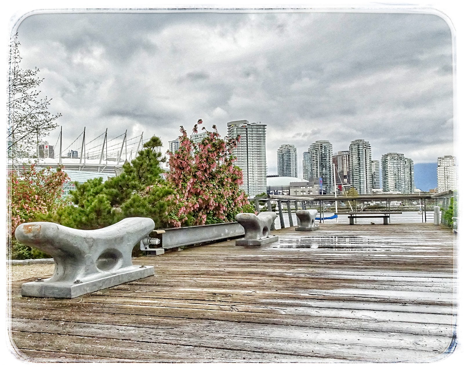
Vancouver - Olympic Village
On a visit with Mom (2017-04-17), it was great to get down to Granville Island and then take one of the little sea busses to the Olympic Village. Once we disembarked from the vessel we took a stroll around the area. In this picture, BC Place Stadium is visible to the left; the water is False Creek.
![]() |
| View from Vancouver's Olympic Village... |
Clinton - Snowy Highway...
This picture, taken on the last day of the year (2016-12-31), was never really supposed to be. As it happened, the province was inundated with snow storms, and BKR had to get back to Quesnel. I thought I'd accompany her on her snowy journey. All was well on our trip north and we had worried needlessly about impassable roads. We were making good time, and could see ourselves making Quesnel before it was too late in the day. That is, until a traffic accident just south of Cache Creek sent us on a detour through Merritt and then through Kamloops. By the time we arrived at Cache Creek, via the detour, it was late and discretion suggested an overnight stay in Clinton.
![]() |
| Last day of 2016 in Clinton... |
Labels:
2016,
British Columbia,
Cariboo,
Clinton,
frtzw906
Location:
Clinton, BC V0K, Canada
Friday, July 21, 2017
Quesnel - Riverfront Trail
It's May (2016-05-08), so there's a good chance we're in Quesnel. And, when in Quesnel, why not take a stroll on Riverfront Trail? The May sun was warming things up and Spring was everywhere.
![]() |
| Quesnel: Riverfront Trail... |
Labels:
2016,
British Columbia,
Cariboo,
Fraser River,
frtzw906,
Park,
Quesnel,
River,
Trail
Location:
Quesnel, BC, Canada
Pavilion - Marble Canyon Provincial Park
Usually, our Cariboo trip is in May. In 2014, our May was booked with London and Portugal. So it was that we visited Quesnel in the middle of June. Coming south on this day (2014-06-18), we opted for a break at the Marble Canyon Provincial Park. Surprisingly, the picnic area was deserted.
![]() |
| Marble Canyon picnic area... |
Monday, July 17, 2017
Mayne Island - Georgina Point Lighthouse Park
Shortly after disembarking at the Village Bay ferry terminal - and being unsuccessful in our search for a place to eat - we opted for an exploration of the park at the Georgina Point Lighthouse. If I were a permanent resident of Mayne Island, I'm sure I'd be a frequent visitor to this place. (2016-09-25)
![]() |
| Looking over to Sturdies Bay on Galliano Island... |
Labels:
2016,
Beach,
British Columbia,
frtzw906,
Gulf Island,
Historic,
Island,
Mayne Island,
Park,
Salish Sea,
Trail,
Vancouver Island
Location:
Mayne Island, BC V0N 2J1, Canada
Thursday, July 13, 2017
Vancouver - Granville Island
Easter weekend saw me visiting Mom in Vancouver. We took this opportunity to check out Granville Island and then have lunch in the Olympic Village. The ride on the little False Creek ferry was a first for Mom.
| Granville Island (2017-04-117) |
Friday, February 19, 2016
Sointula - Dockside Details
After breakfast at the little (only perhaps?) bakery by the ferry terminal, we were off to a little Sointula sightseeing. While the fishing fleet on Malcolm Island may not be as large as in days of yore, the government docks and the many boats in Sointula still seemed fairly large (compared to Nanaimo, anyway). As usual, I find it hard to resist dockside details. <Click!>
2016-02-09 Sointula dockside details
Labels:
2016,
Boat,
British Columbia,
Dock,
frtzw906,
Island,
Sointula,
Vancouver Island,
Water,
Wharf
Location:
Sointula, BC, Canada
Friday, February 12, 2016
Telegraph Cove: All's Quiet in February
After a couple of sunny February days on Malcolm Island (Sointula), our drive home took us to rainy Telegraph Cove. We were quite surprised; there was much more to see than we had anticipated. In fact, we've decided another trip, in warmer weather, should be planned.
| 2016-02-10 Telegraph Cove |
Labels:
2016,
Boat,
British Columbia,
Dock,
Historic,
Telegraph Cove,
Vancouver Island
Location:
Telegraph Cove, BC V0N, Canada
Thursday, March 19, 2015
Crofton - Seawalk
On this November morning we opted for a drive down island. With no rain to keep us indoors, we stopped in Crofton to have a look at an Arts exhibition and to stroll along a very nice seawalk.
![]() |
| Crofton - Seawalk (2013-11-16) |
Labels:
2013,
Beach,
Bridge,
British Columbia,
Cowichan Valley,
Crofton,
frtzw906,
Vancouver Island
Location:
Crofton, BC, Canada
Tuesday, June 24, 2014
Steveston - Finn Slough
On a foggy January afternoon, after some fish and chips along the Steveston Wharf, we took a drive out to Finn Slough. I had once read that Finn Slough is one of the most photographed locations in British Columbia's Lower Mainland. Whether true or not, CLICK!, one postcard view after another. I think "quaint" and "unique" sum up this area.
![]() |
| Finn Slough in Steveston (Richmond, BC) 2014-01-26 |
Labels:
2014,
Boat,
British Columbia,
Fraser River,
Richmond,
Steveston,
Water
Location:
Finn Slough, Richmond, BC, Canada
Monday, June 23, 2014
Vancouver - The Trans Canada Trail at Coal Harbour
Felix and I did a quick one-day tour of Vancouver in early January. For the previous few days, the west coast of British Columbia had been shrouded in fog. This day was no exception. Nonetheless, Vancouver showed itself in true postcard fashion. Here we see the Trans Canada Trail at Coal Harbour.
![]() |
| The Trans Canada Trail at Coal Harbour 2014-01-20 |
Labels:
2014,
British Columbia,
Trail,
Vancouver,
Water
Location:
Coal Harbour, Vancouver, BC, Canada
Saturday, June 21, 2014
Spuzzum - Alexandra Bridge
On our circular tour of south western British Columbia, Norbert and I spotted the turn-off to Alexandra Bridge Provincial Park. For years I'd been wanting to come here to view the old bridge but, for some reason, had always missed the entrance. This time, coming south along Highway 97, I got lucky.
It's just a short walk from the parking lot to the old bridge itself. The walk is worth it, if only to feel and hear the might of the Fraser River. I suppose, this being late June, the river was running particularly high.
![]() |
| Alexandra Bridge over the Fraser River 2013-05-24 |
Labels:
2013,
Bridge,
British Columbia,
Fraser River,
frtzw906,
Historic,
Park,
River,
Water
Barkerville - Miner's Log Cabin
Our visit to Barkerville, the historic Cariboo goldrush town, would not have been complete without a postcard of the log cabins so characteristic of this region in the 1860s. Here's one with an added lean-to.
| Miner's log cabin in Barkerville 2014-06-14 |
Labels:
2014,
Barkerville,
British Columbia,
Cariboo,
frtzw906,
Historic,
Park
Location:
Cariboo C, BC, Canada
Barkerville - St. Saviour's Anglican Church
On a chilly mid June day, we drove out to Barkerville. Although we've been here many times before, this old historic goldrush town is always worth a visit. For the photographer, there are hundreds of opportunities to get nice pictures. In this case, the subject of the postcard is St. Saviour's Anglican Church, an historic one-storey rustic Carpenter Gothic Anglican building. Construction of the church began in 1868, once transport routes to this remote Cariboo location had been improved. The church was not finished until after the first service, held on September 18, 1870. Today it is part of Barkerville Historic Town.
| St. Saviour's Anglican Church; one-storey rustic Carpenter Gothic Anglican church in Barkerville 2014-06-14 |
Labels:
2014,
Barkerville,
British Columbia,
Cariboo,
Church,
frtzw906,
Historic,
Park
Location:
Cariboo C, BC, Canada
Ladner - Fraser River Navigation Beacon
Although the Fraser River was running quite high in early July, a bunch of us went kayaking out of Ladner. Here, in this Postcard, we pass by a navigation beacon.
![]() |
| Navigation light in the Fraser River, near Ladner 2006-07-05 |
Labels:
British Columbia,
Fraser River,
frtzw906,
Ladner,
River,
Water
Location:
Delta, BC, Canada
Thursday, June 5, 2014
Quesnel - Wooden Footbridge Across the Fraser River
While we were in Quesnel, visiting Britt, a stroll along the banks of the Fraser River brought us to this wooden footbridge.
![]() |
| Wooden Footbridge Across the Fraser River in Quesnel 2013-05-02 |
Labels:
Bridge,
British Columbia,
Cariboo,
frtzw906,
Quesnel
Location:
Quesnel, BC, Canada
Osoyoos - Dusty Road Through Semi-Arid Landscape
While we were visiting the Okanagan Valley with Paul and Beate, we decided to take a road trip south to Osoyoos. While visiting the Nk'Mip Desert Cultural Centre, we found ourselves virtually alone on this dusty Osoyoos road through a semi-arid landscape.
![]() |
| Dusty Osoyoos Road Through a Semi-Arid Landscape at the Nk'Mip Desert Cultural Centre2013-07-17 |
Lytton - Where the Thompson and Fraser Rivers Meet
Along the CN railway line, in Lytton, where the Thompson and Fraser Rivers meet.
![]() |
| Along the CN railway line in Lytton, where the Thompson and Fraser Rivers meet 2012-09-13 |
Labels:
British Columbia,
Fraser River,
frtzw906,
Lytton,
River,
Water
Location:
Lytton, BC, Canada
Tofino - The Harbour Wakes up as the Sun Rises
As we waited for our boat to Hot Springs Cove be be ready, I couldn't resist this shot of Tofino in the morning.
| Early morning in Tofino Harbour 2014-04-12 |
Labels:
Boat,
British Columbia,
Dock,
frtzw906,
Mountains,
Tofino,
Vancouver Island,
Water
Location:
Tofino, BC, Canada
Thursday, December 12, 2013
Okanagan Valley - a Quiet Afternoon at Chute Lake
After a lengthy spell of rainy weather in Naramata, the downpour stopped. Marco and I took the opportunity to explore the Trans Canada Trail (Kettle Valley Railroad section) above St. Georg's vineyard. Eventually, our travels took us to Chute Lake.
![]() |
| Chute Lake: deserted in August (2013-08-27) |
Sunday, November 24, 2013
Indian Arm - Stopping off at Twin Islands
The view northward (old hydro power generating station in the distance) from the smaller of the two Twin Islands. The larger of the two islands is on the other side of the lagoon below.
![]() |
| August 21, 2006 |
Labels:
British Columbia,
frtzw906,
Indian Arm,
Island,
kayak,
Mountains,
North Vancouver,
Park,
Vancouver,
Water
Location:
Belcarra, BC, Canada
Saturday, September 28, 2013
Indian Arm - Power Station #2
After a launch at Deep Cove, my kayak trip took me along the west shore of Indian Arm, up to Best Point, where I then crossed the inlet over to Buntzen Bay. A short while later, I paddled around in the vicinity of the two old, historic power stations that used to be fed from Buntzen Lake.
| Looking north along Indian Arm at Power Station #2 (2006-08-24) |
Labels:
British Columbia,
frtzw906,
Historic,
Indian Arm,
North Vancouver,
Vancouver,
Water
Location:
Greater Vancouver, BC, Canada
Thursday, September 12, 2013
Pavilion - Cowboy Country on the Diamond-S Ranch
In early May, the highway between Hat Creek Ranch and Lillooet led us past the ranching country around Pavillion. As luck would have, while speeding by, we noticed a cloud of dust rising from a roadside corral. We turned around to investigate. To our surprise, we happened upon the cowboys of the Diamond-S Ranch rounding up calves for the spring branding and inoculation. Clearly POSTCARD stuff.
| Cowboys of the Diamond-S Ranch rounding up calves for the spring branding and inoculation(2013-05-04) |
Location:
Pavilion, BC V0K, Canada
Monday, September 2, 2013
Port Alberni - Welcome at Victoria Quay
Too often, when on the way to Pacific Rim Park, travellers scoot through Port Alberni without really looking around. On this occasion, we stopped at the little Victoria Quay park across from the highway junction to look at the Somass River and admire the First Nations welcoming figure, created by Hupacasath carvers.
| First Nation welcoming figure (2010-03-19) |
Sunday, September 1, 2013
Peachland - Taking a Break along the Lakeshore
Between Clinton in the Cariboo, and Naramata in the Okanagan Valley, we stop for a bite to eat in Peachland. With about 11 kilomters of foreshore, the village itself provides visitors with an enjoyable drive and pleasant Okanagan Lake vistas.
| Peachland Lakeshore (2013-07-16) |
Location:
Peachland, BC, Canada
Tuesday, August 13, 2013
Saltspring Island - Ruckle Farm
Mid September took us to Saltspring Island for the annual fall fair. After wandering about the fairgrounds we decided to do some sightseeing at Ruckle Provincial Park where we stopped to admire a postcard view of the old Ruckle farm.
120915
| Buildings associated with the old Ruckle farm at Ruckle Provincial Park (2012-09-15) |
Labels:
British Columbia,
frtzw906,
Historic,
Island,
Park,
Saltspring Island
Location:
Capital, BC, Canada
Monday, August 12, 2013
Whistler - Plenty of Mountain Biking in the Spring
On our journey from Horseshoe Bay (Nanaimo, actually) to Lillooet, we stop for lunch at Whistler. It's May, and we encountered a few skiers and boarders in the parking lot. However, it's clear that this is Spring, and those seeking snow must make for the top of the slopes. Not to worry. There's plenty of action on the lower slopes for bikers. On this day, the village is a-buzz with mountain bikers ready to take on the hills.
130523
| Whistler is a mountain biker's Mecca in Spring |
Monte Lake - Taking a Break
The day of this postcard setting features a lengthy drive from Clinton to Naramata. At Monte Lake, we pull over to stretch our legs and to enjoy the lake scenery.
| Taking a break from a long drive at Monte Lake (2013-07-16) |
Location:
Monte Lake, BC V0E, Canada
Sunday, August 11, 2013
Buckley Bay - a Blue Heron Keeps an Eye on Ferry Traffic
On our trip over to Denman Island and then Hornby Island, we spot a heron keeping a watchful eyes on the comings and goings on the beach at Buckley Bay.
| Buckley Bay heron (2007-08-25) |
Horseshoe Bay - Waiting for a BC Ferry
Waiting for a ferry at Horseshoe Bay is as good a time as any to take some pictures of the government dock and the many boats in the marina.
| The government and marina docks around Horseshoe Bay (2013-06-12) |
Porteau Cove - A Look up Howe Sound from Porteau Cove
Our July trip up the Sea-to-Sky highway took us past Porteau Cove; always a great spot for a photo-op.
| Looking up Howe Sound, along the Sea to Sky Highway (2013-07-15) |
Labels:
British Columbia,
frtzw906,
Howe Sound,
Mountains,
Park,
Porteau Cove,
Sea to Sky,
Water
Location:
Squamish-Lillooet D, BC, Canada
Lillooet - Details of the 23 Camels Bridge
A road trip in May took me up to Lillooet. One of the things to see in Lillooet is the historic 23 Camels Bridge, not too far from the centre of the village. My camera was attracted to the rusty fixtures.
| Details of the 23 Camels Bridge in Lillooet British Columbia (2013-05-23) |
Labels:
Bridge,
British Columbia,
Fraser River,
frtzw906,
Historic,
Lillooet,
Park,
Rust
Location:
Lillooet, BC, Canada
Subscribe to:
Posts (Atom)


.jpg)


