Showing posts with label Water. Show all posts

Friday, August 28, 2020

French Creek

 So far, this June hadn't been much of a summer. Nonetheless, the cloudy days were great for getting out and exploring beaches. This day (2020-06-22) found us snooping around beaches just south of Qualicum Beach. Here is a "postcard" from the banks of French Creek (with the French Creek harbour in the distance).

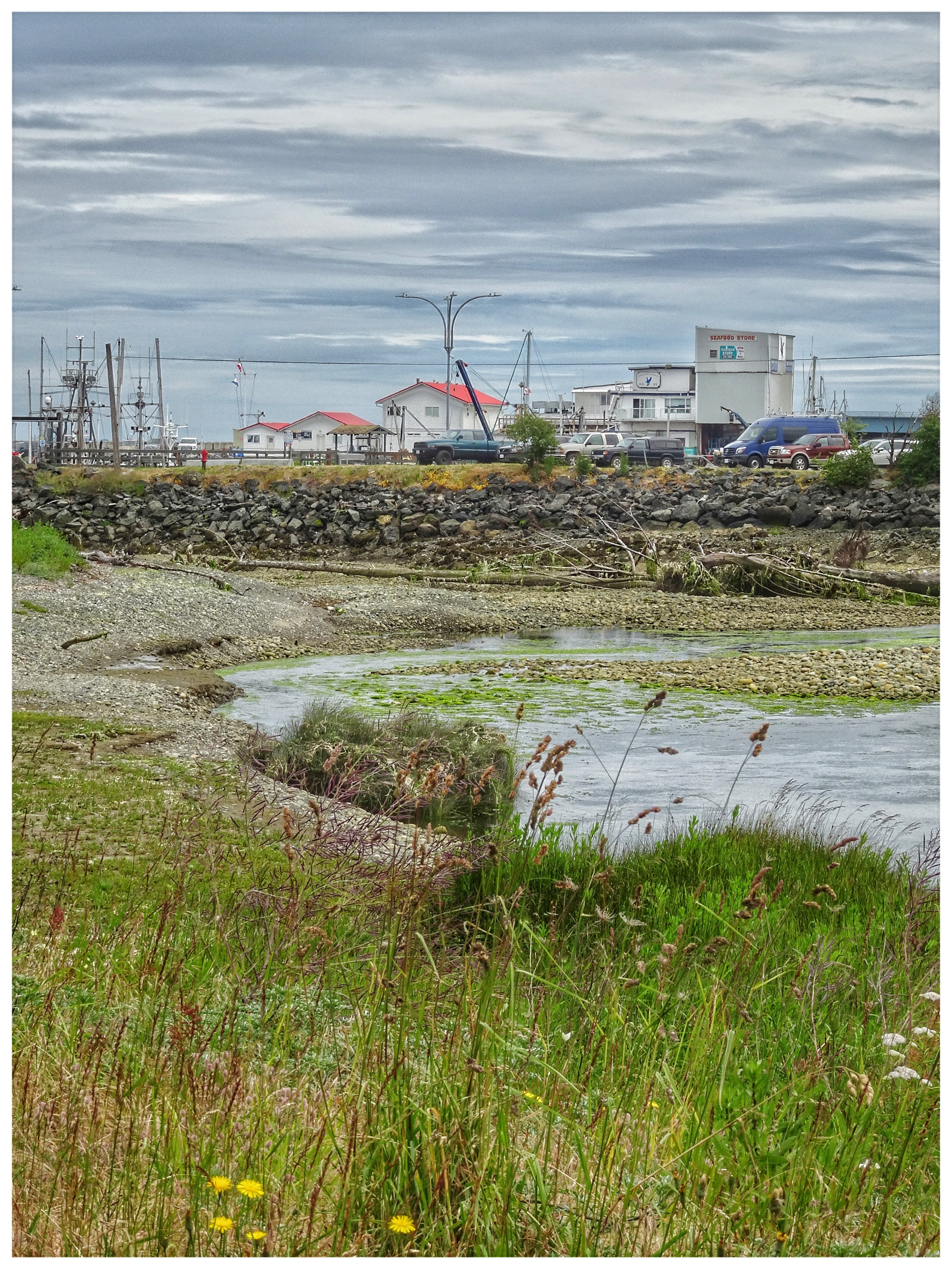
Banks of French Creek (2020-06-22)


Thursday, August 27, 2020

Deep Bay - Colourful Dockside Details

During this generally grey June (2020-06-27), it was time to get out of the house and visit a place we hadn't been to for a few years. I love boats, so the Deep Bay docks have a particular appeal. Specifically, I'm drawn to dockside details.

Deep Bay dockside details and colours (2020-06-27)
Deep Bay (2020-06-27)

Sunday, July 23, 2017

North Vancouver - Lone Rock Point in Indian Arm

On this gorgeous day in August (2006-08-31), Hanne and I set off kayaking, heading for Jug, Raccoon, and Twin Islands. We launched in Deep Cove and made our way along the North Vancouver shore before planning to cross Indian Arm, over to our destination islands. Off the shore we took our postcard picture at Lone Rock Point.

Lone Rock Point in Indian Arm...

Vancouver - Olympic Village

On a visit with Mom (2017-04-17), it was great to get down to Granville Island and then take one of the little sea busses to the Olympic Village. Once we disembarked from the vessel we took a stroll around the area. In this picture, BC Place Stadium is visible to the left; the water is False Creek.

View from Vancouver's Olympic Village...

Friday, July 21, 2017

Pavilion - Marble Canyon Provincial Park

Usually, our Cariboo trip is in May. In 2014, our May was booked with London and Portugal. So it was that we visited Quesnel in the middle of June. Coming south on this day (2014-06-18), we opted for a break at the Marble Canyon Provincial Park. Surprisingly, the picnic area was deserted.

Marble Canyon picnic area...

Thursday, July 13, 2017

Vancouver - Granville Island

Easter weekend saw me visiting Mom in Vancouver. We took this opportunity to check out Granville Island and then have lunch in the Olympic Village. The ride on the little False Creek ferry was a first for Mom.

Granville Island (2017-04-117)

Friday, February 19, 2016

Sointula - Dockside Details

After breakfast at the little (only perhaps?) bakery by the ferry terminal, we were off to a little Sointula sightseeing. While the fishing fleet on Malcolm Island may not be as large as in days of yore, the government docks and the many boats in Sointula still seemed fairly large (compared to Nanaimo, anyway). As usual, I find it hard to resist dockside details. <Click!>

2016-02-09 Sointula dockside details

Tuesday, June 24, 2014

Steveston - Finn Slough

On a foggy January afternoon, after some fish and chips along the Steveston Wharf, we took a drive out to Finn Slough. I had once read that Finn Slough is one of the most photographed locations in British Columbia's Lower Mainland. Whether true or not, CLICK!, one postcard view after another. I think "quaint" and "unique" sum up this area.


 Finn Slough in Steveston (Richmond, BC) 2014-01-26
 Finn Slough in Steveston (Richmond, BC) 2014-01-26

Monday, June 23, 2014

Vancouver - The Trans Canada Trail at Coal Harbour

Felix and I did a quick one-day tour of Vancouver in early January. For the previous few days, the west coast of British Columbia had been shrouded in fog. This day was no exception. Nonetheless, Vancouver showed itself in true postcard fashion. Here we see the Trans Canada Trail at Coal Harbour.

The Trans Canada Trail at Coal Harbour 2014-01-20

Saturday, June 21, 2014

Spuzzum - Alexandra Bridge

On our circular tour of south western British Columbia, Norbert and I spotted the turn-off to Alexandra Bridge Provincial Park. For years I'd been wanting to come here to view the old bridge but, for some reason, had always missed the entrance. This time, coming south along Highway 97, I got lucky.

It's just a short walk from the parking lot to the old bridge itself. The walk is worth it, if only to feel and hear the might of the Fraser River. I suppose, this being late June, the river was running particularly high.

Alexandra Bridge over the Fraser River 2013-05-24

Ladner - Fraser River Navigation Beacon

Although the Fraser River was running quite high in early July, a bunch of us went kayaking out of Ladner. Here, in this Postcard, we pass by a navigation beacon.


Navigation light in the Fraser River, near Ladner 2006-07-05

Thursday, June 5, 2014

Lytton - Where the Thompson and Fraser Rivers Meet

Along the CN railway line, in Lytton, where the Thompson and Fraser Rivers meet.

Along the CN railway line in Lytton, where the  Thompson and Fraser Rivers meet 2012-09-13
Along the CN railway line in Lytton, where the
Thompson and Fraser Rivers meet 2012-09-13


Tofino - The Harbour Wakes up as the Sun Rises

As we waited for our boat to Hot Springs Cove be be ready, I couldn't resist this shot of Tofino in the morning.

Early morning in Tofino Harbour 2014-04-12

Thursday, December 12, 2013

Okanagan Valley - a Quiet Afternoon at Chute Lake

After a lengthy spell of rainy weather in Naramata, the downpour stopped. Marco and I took the opportunity to explore the Trans Canada Trail (Kettle Valley Railroad section) above St. Georg's vineyard. Eventually, our travels took us to Chute Lake.

Chute Lake: deserted in August (2013-08-27)


Sunday, November 24, 2013

Indian Arm - Stopping off at Twin Islands

The view northward (old hydro power generating station in the distance) from the smaller of the two Twin Islands. The larger of the two islands is on the other side of the lagoon below.

August 21, 2006

Saturday, September 28, 2013

Indian Arm - Power Station #2

After a launch at Deep Cove, my kayak trip took me along the west shore of Indian Arm, up to Best Point, where I then crossed the inlet over to Buntzen Bay. A short while later, I paddled around in the vicinity of the two old, historic power stations that used to be fed from Buntzen Lake.

Looking north along Indian Arm at Power Station #2 (2006-08-24)
Looking north along Indian Arm at Power Station #2 (2006-08-24)

Sunday, September 1, 2013

Peachland - Taking a Break along the Lakeshore

Between Clinton in the Cariboo,  and Naramata in the Okanagan Valley, we stop for a bite to eat in Peachland. With about 11 kilomters of foreshore, the village itself provides visitors with an enjoyable drive and pleasant Okanagan Lake vistas.

Peachland Lakeshore (2013-07-16)
Peachland Lakeshore (2013-07-16) 

Monday, August 12, 2013

Monte Lake - Taking a Break

The day of this postcard setting features a lengthy drive from Clinton to Naramata. At Monte Lake, we pull over to stretch our legs and to enjoy the lake scenery.

Taking a break from a long drive at Monte Lake (2013-07-16)
Taking a break from a long drive at
Monte Lake (2013-07-16)

Sunday, August 11, 2013

Buckley Bay - a Blue Heron Keeps an Eye on Ferry Traffic

On our trip over to Denman Island and then Hornby Island, we spot a heron keeping a watchful eyes on the comings and goings on the beach at Buckley Bay.

Buckley Bay heron
Buckley Bay heron (2007-08-25)

Horseshoe Bay - Waiting for a BC Ferry

Waiting for a ferry at Horseshoe Bay is as good a time as any to take some pictures of the government dock and the many boats in the marina.

The government and marina docks around Horseshoe Bay
The government and marina docks
around Horseshoe Bay (2013-06-12)